Why would one build a railway in the middle of a motorway? It's cheaper!
Why would you avoid grade-separating railways, either through tunnelling ground or having them elevated? In short: cost (acquiring land and compensating owners, etc)
Where the Elizabeth Line's construction costs surpassed $25 billion tunnelling through central London, there is only lane widening to consider for motorways (unless already had a convenient median).
I name it: Lorbit.
'Lo' from London and 'orbit' from... London Orbital Motorway, known simply as the M25.
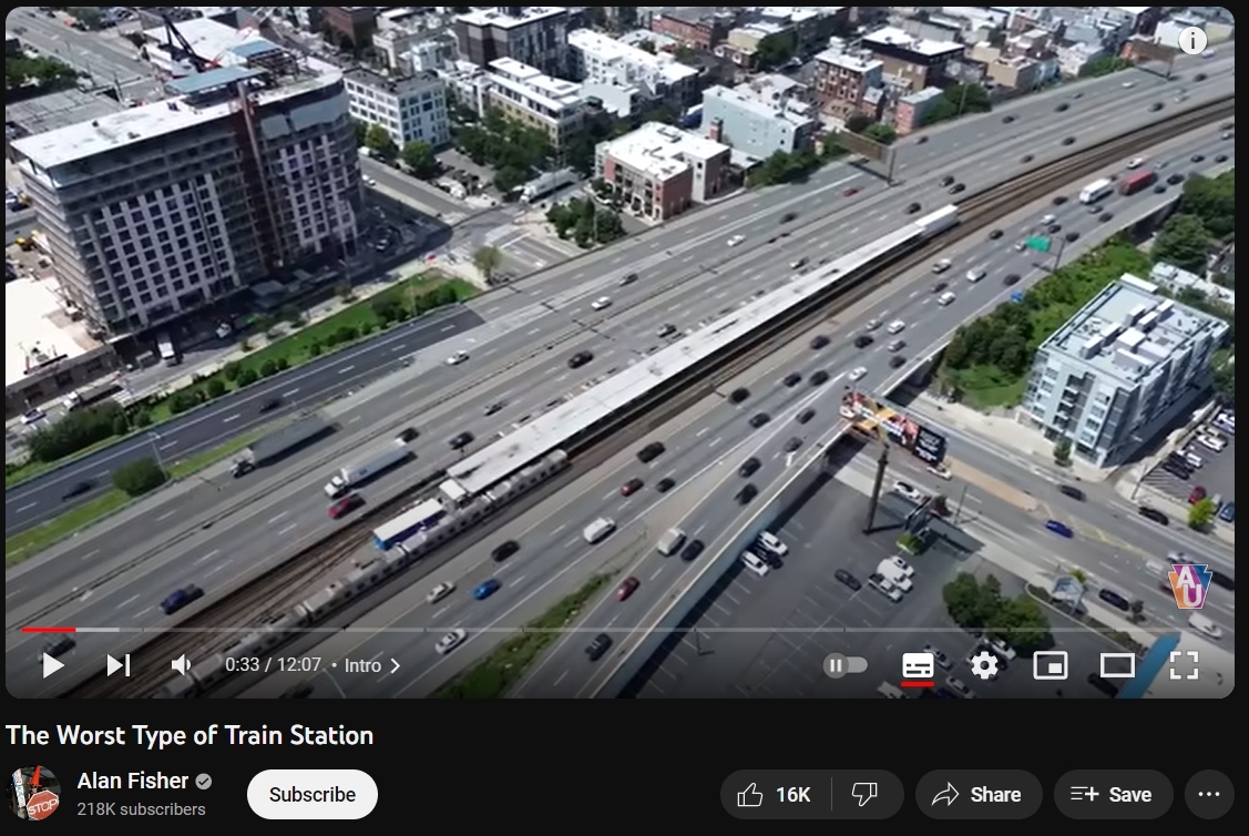
A little while ago in Canada Montreal's newest metro on the block: REM automated light rail system along the freeway.
 |
| I increased my budget with my own animated GIF |
It's not uncommon in America too, usually in cases the freeway came after the railway.
Or see Roosevelt Boulevard, it already has a median built into it in preparation for a subway that is 20-years in bickering over finances.
If it's not obvious, America had the most railway track in any country in the 19th-20th centuries, well, I didn't try as it's not the main topic but alas, some things confined to the past.
So you have Chicago, Los Angeles, Philadelphia but to name a few that have this... quirk of the transport world.
 | |
|
In Berlin the autobahn (highway in English) was built 50 years after the Ringbahn (S-bahn/U-bahn trains that form a ring in the city).
Osaka in Japan also has some section of this description, albeit 4-lane for cars rather than the monstrosities you see in North America.
Perth also has a 10-lane freeway with a bus lane on the outsides, and a railway in the middle. They're going to extend the line, costing only $441 million AUD projected as of writing.
The consensus is highway median railways like these are bad, after all in those stations on the motorway - you're blasted with the sound of tyre friction that surpass 90 dB (think of being in a concert level of loudness), whilst every waking second feels longer than it actually is, as your perception is slightly warped by how uncomfortable it is to be there, even with some level of sound proofing.
Then, catchment.
Where are you placing stations to appeal to people that won't drive their car? A decent amount of catchment area is taken by the motorway itself. Therefore the areas the stations are in should be a destination despite these shortcomings, to be considered usable.
So I had a thought, is this doable with our M25?
Highway median railways, what could possibly go wrong?!
Let's investigate,
- reducing it to two lanes and placing rail tracks
or
- widen M25 an extra road lane per direction, adding rail tracks in-between
For reference in my previous rail-related post, I did draw about an orbital Overground line at the bottom of my post about South London and trains (I didn't think of this on my own, ideas spurred by other bus enthusiasts discussion), which would vaguely parallel inside the M25 going to major centres.
 |
| Freeze frame Spot the train, I'll give you all the time |
Spring Garden being one of the worst designed stations, it's in Philadelphia.
Where do we start, we were meant to have four orbital motorways;
The inner-most scrapped - too many buildings would be demolished.
The second ring had parts of it constructed (most of A406) but mostly undone.
The third ring parts of it constructed, rushedly turned into M25.
The outer ring is the majority of the M25 as we have today.
Obviously the M25 being the single motorway that does the job of more than 2 intended motorways, it's been a hotbed of a mess.
Lane widenings in key areas have only gone so far. If it was even possible to instantly widen all the lanes, you'd end up with a positive feedback loop experienced in many American freeways (see that 18 lane LA monstrosity - traffic still bad)
Therefore, it is imperative there is public transport, namely trains, that also orbit London. We have the London Overground that does a great job of orbiting inner London. We need that replicated in outer London and perhaps even the border of London in order to reduce strain on networks, mainly reducing traffic.
Ideally you'd have completely grade-separation for this job, most likely requiring either mass-tunnelling (very expensive very quickly) or acquiring a lot of land, which is possible - can that satiate the many buildings that would be bulldozed as well as farm plots reduced... who knows, I'm merely typing a fantasy that isn't completely stupid albeit almost unreasonable by British standards.
On the assumption using the M25 is a lesser evil, then:
Costs:
For starters, new stations you're looking upwards of a £1 million, as much as £10 million. The likes of Reading Green Park which opened recently costing £6-8 million.
There's a segment below about stations and I've come up with 20 in my reasonable opinion, so up to £200 million on stations alone.
Car parking garages cost about £25 thousand, we'd roughly want that for every station with less-than-adequate public transport.
Twenty stations again add this cost to £500,000.
Rolling stock (including new depot) would cost a fair bit, Elizabeth Line with 70 trains estimated cost £1 billion.
New bus stations - West Croydon cost £4.5 million, even if it is a rebuild. Up to 15 stations are doable with bus connections, Heathrow is ruled out (already has bus stations to connect to), some locations not ideal for bus stations for the stations I've made (Brentwood parkway, basically only 498 can use it) but still should be done to facilitate ease of transfer onto this Lorbit Line.
Costs up to £67,500,000
Extra buses to schedules
(£200,000 to operate each roughly, 252 294 370 might require +1, 234 require +3).
TfL costs amount to under £1,000,000.
No non-TfL costs accounted for; on themselves or on councils fortunately and unfortunately.
Not widening the M25 (i.e reducing road lanes) would definitely be cheaper and definitely be more disruptive short-term, perhaps even still moderately disrupted medium-term if there isn't adequate destinations transferred from the car to this railway.
Again, rail costs (Excluding land acquisition) between £12-20 million per mile. So £2,340 million,
Widening the M25 would cost a fair bit per mile, one of last motorway widening was... the very M25 itself! For a short distance, £272 million (£16.2 million per mile) in 2002 figures. £28m/mile in 2023 money.
M1 widening projected to be £21 million per mile in 2007. That's £33m/mile in 2023 money.
Using those numbers to do the same to the whole 117 mile long motorway would cost £7,722 million. Several billion of course.
Granted, it won't work like that in reality(Excluding land acquisition), so it may be more expensive, no amount of optimism allows for it to be as cheap as 2002 (accounting for inflation).
Again, rail costs (Excluding land acquisition) between £12-20 million per mile. So £2,340 million.
Rudimentary maths total: £10,331,000,000.
That's before land acquisition, contracts, construction delays, pushing costs higher.
That is also before bureaucratic paperwork, which cost £271 million for the Lower Thames Crossing for paperwork and not beginning construction. Compare that to the Faroe Islands undersea tunnels which has a roundabout which was constructed for around €50 million.
That is also before business case study which is mostly a waste of resources only to answer 'yes' to an obvious question of 'if this is a benefit?'
Difficulties from an armchair perspective
Widening the tunnel under Waltham Cross could be impossible, let alone prohibitively costly.
Crossing the Thames (east side), given there is a tunnel and bridge on M25.
Heathrow area.
 |
| I forgot to add "Parkway" to differentiate most stations not connected to namesake areas |
Projected demand:
Put simply, over 200,000 daily vehicles use the M25 (over 8,333 an hour). 15% of UK motorway traffic. Let's put that to scale quickly.
 |
| Cars; 4 kilometres of road space 1 train; 200m of space Only 6 Class 345s an hour needed to meet the hourly estimated use of M25 |
So roughly, assuming at least half of them are car traffic, of which most only have the driver in them, then you'd get a quick maths like the above but worse.
Yikes.
Stations:
Dartford parkway (96 428 to serve it)
Swanley
[Branch A] Orpington
[Branch B] Sevenoaks
Oxted parkway
Godstone parkway (434 466 extended there)
< new tunnel >
Redhill
[Branch from east] Gatwick Airport
> new tunnel end >
Leatherhead parkway (465 serves it, 293 extended there)
Byfleet parkway (for Byfleet and West Byfleet)
Chertsey parkway
Heathrow Terminal 5 (important)
Heathrow Terminal 2 & 3 (important)
Iver
Gerrards Cross parkway
Rickmansworth parkway
Kings Langley
[Branch] Hemel Hempstead to/from Luton
< new tunnel >
Watford Junction
St Albans City
< new tunnel end >
Potters Bar parkway (234 extended there)
Waltham Cross parkway
Epping parkway (397 extended there)
Brentwood parkway (connect with Elizabeth Line, new station. 498 rerouted into it. 252 and 294 extended from Noak Hill via newly built road.)
Upminster Parkway (248 extended there)
Lakeside parkway (for Lakeside shopping centre and West Thurrock. 370 + non-TfL buses extended)
All stations with bicycle parking space, like in the Netherlands.
All of the above with bus stations on top of the stations or in very close proximity with step-free access.
Taking a page out of Hong Kong and Japan playbooks, every station must be a destination in order to guarantee great usage at each station. Hong Kong made most rail stations actual shopping malls. Japan's rail companies buy and own the land surrounding the station and they build residential property on the land.
What we can do is certainly apply both but each station should be looked at differently, especially places like Watford and St Albans which are guaranteed destinations.
Separately, tube lines extended to meet this Lorbit Line, firstly as Bakerloop-style bus versions beforehand as it is cheaper and also sees if such extensions are viable.
District Line extended to Upminster Parkway
Liberty Line extended beyond Upminster Parkway parallel to Lorbit Line to...? [maybe Heathrow vaguely via SL7 to replace SL7]
Hammersmith & City extended go ...
Piccadilly Line from Cockfosters to Potters Bar Parkway
Northern Line from High Barnet to Potters Bar Parkway
Jubilee Line from Stanmore to London Colney
Central Line from West Ruislip to Gerrards Cross
Victoria Line from Brixton with many stations parallel on A23 and West Croydon and East Croydon all the way to Coulsdon and then Redhill
Metropolitan on Watford branch diverted to Watford Junction via Watford High Street with Watford station replaced by new Cassiobury Station.
West Midlands' St Albans Abbey branch line (Watford Junction to St Albans Abbey) turned into a Tramlink-style tram-train line St Albans Abbey station removed and new tunnel to serve St Albans City, then extended via Hatfield, Welwyn Garden City, Hertford, Ware, Roydon, Harlow, Stansted Airport, Chelmsford, Wickford, Rayleigh, Hockley, Rochford, Southend Airport, Prittlewell, Southend. Increased from every 60 minutes to minimum every 20 minutes or more frequent if paths are available. Made to serve Watford Town Centre and St Albans town centre.
Great Western Railway's North Downs Line (Reading via Guildford and Redhill to Gatwick) converted into light-rail tram-train with frequency of every 20 minutes during daytimes and removal of all semi-fast and serves town centres, can be connected with tram-train converted Redhill-Tonbridge line. Deviates from Brighton Main Line to serve East Surrey Hospital.
Southern's Redhill-Tonbridge line and Southeastern's Medway Valley line (Paddock Wood to Maidstone West) converted to one light-rail tram-train line which serves town centres, frequency increased to every 20 minutes in daytime (30 outside daytime). Extended to Gatwick Airport. Deviates off Brighton Main Line to serve East Surrey Hospital.
Marlow branch line reconnected to High Wycombe and converted into light-rail tram-train that extends to serve Amersham, Hemel Hempstead and St Albans town centre.
New cycle paths that link to these stations explored.
There were some sparse locations where, in hindsight would seem wasteful, though in reality no guarantee traffic wouldn't generate more than I anticipate if this came to reality. After all, many stations in the northern outreaches of the tube were desolate fields when extended, at a time before the Green Belt was established post-war, putting a dead end to many projects, notably for us Londoners - the Northern Heights Plan that would've seen Bushey Heath on the tube map, and Edgware connected to Mill Hill by Northern Line.
Timetable
It takes about 2 hours to do a loop of the M25, look up on YouTube.
National speed limit on cars is 70mph.
We want speed, so trains can do 100mph and even exceed 125mph. We have plenty of those. Cutting costs to light-rail sacrifices speed, necessary for long distances between stops - unlike short stops between DLR or Tramlink.
Referencing the Joondalup Line again, trains have a maximum speed of 80mph where freeways tend to be 68mph or less.
By nature of the M25 serving Heathrow traffic and being down the line from Gatwick at it's southern tip as well as serving many centres, the routes chosen should be really well thought out and with data. Some things I do lack as I am just an armchair enthusiast.
Journey time around 100-120 minutes is my ballpark figure, not much below doing the M25 in a car yourself.
Segregated vs Interconnected
The pro with segregated is minimal delays from being interconnected, the likes of our Sub-surface lines and other similar lines globally do face the same issue. One problem somewhere on the line impacts all the lines to some degree.
The con with segregated is the very limited connections one can do.
Conversely, the pro with being interconnected is the many destinations one could achieve. The cross-London service from [almost]Oxford to Brighton can make a comeback using this M25 rail. Others could also be created.
In addition, other local lines could be added/diverted to use the tracks. Even in cases of diversions this will doubly be handy.
Ashford via Dartford to Heathrow
Brighton via Gatwick to Oxford
Southend - Potters Bar - Luton
Guildford to Stansted
2026 edit:
Brighton via Gatwick and Stansted to Cambridge
Southend via Potters Bar Parkway to Oxford
Portsmouth via Heathrow, Hemel Hempstead and Luton to Northampton (or further to Leicester)
Dover via Leatherhead Parkway to Bristol
The above long-distance destinations allow for higher passenger usage whilst reducing strain inside Central London's rail network, and taking kilometres of cars off the motorways.
This would be further improved by connecting major cities outside London like with the Northern Powerhouse Rail which will link Liverpool, Manchester, Hull and Sheffield, Newcastle and Hull.
I do notice none of my 2026 suggestions link to any of the above, but certainly can be connected to by trains from nearby stations.
 |
| An older idea of mine but using outer London mostly |
What do you think? Not as bad as my Acrossrail photo below maybe? Outrageous idea perhaps? All I'm saying is, if car-centric America continues this practice whilst the Germans/Japanese mostly had the practice happen afterward, then we can replicate the technique, preferably with quality like the Australians did.
Sources/watch these videos too!
...
No comments:
Post a Comment