 |
| pre-Victoria Line PDF link |
A post in the making since 2021, sat on the project a few times. Took a total of many weeks of completely researching and putting into a cohesive script to then make the good eye-catchy maps of artwork. Enjoy, stay safe and well.
 |
| I chose Bakerloo Line over Victoria Line just to choose the easier tube line to draw in my cluttered map |
Streatham High Road - Lambeth's self proclaimed longest high street in Europe at 1.8 miles (when Piotrkowska Street in Poland is 4.2 km long) ignoring Brexit
Norwood Road - my local corridor
I could shower this post with images but for once, I refer you to the folder I've made where you can view the PDFs; 1912; 1942-2002 every decade and 2023.
A few images for those who haven't opened the folder link.
 |
| I realised this literally after uploading the post, I bloody missed Walworth Road station (between Elephant and Camberwell) |


So I was interested in doing this for my town of West Norwood but I jumped the scale by also doing Streatham High Road, starting from Brixton Tram Shed all the way until the Green Lane junction which should really be Norbury on G1's displays but Streatham is superior so very understandable choice made there.
Expanding the tram network

So there was a tube map with the target date of 2016 that I still have, with the Tramlink resurfacing the tram lines from Croydon but to Streatham whilst a new set of tracks link Harrington Road to Crystal Palace station then Crystal Palace Parade thus linking the entire area but this was shelved with costs, despite going to consultation. Not only that, but came back to life with Bojo's second term as Mayor but also died off as quickly.
I was going to include the Bromley extension prayed by Bromley Council in their words, "to relieve the 227" but since this seemed like any other outward claims and seemingly hard to realistically pull off, I've shelved that entirely. As cool yet weird a tram coming in to save a bus is... lest we forget 358 but I will remember you.
Extending tube lines southward

The more expensive but intensive and definitely sustainable way forward is... the tube. Electric rail. The common folk would probably say 'why bother with electric buses' but the hard fact is we're headed there regardless as buses are needed, but the quantity of them can be reduced. Cars being space inefficient, buses much more space efficient but still significantly less space efficient than the superior train. Thankfully in South London where rail coverage is shoddy and simultaneously poor linked in many areas thus making bus the King, we've not had TfL's PR initiative of feeding people on to the tube. Because we don't have a tube. In any case, long live the bus! Tenno heika BANZAI!
Exhibit A:
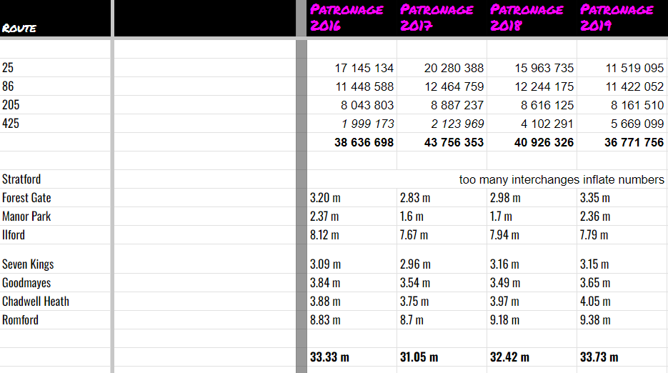 |
| These statistics should favour the train with Elizabeth Line being more frequent now |
Exhibit B:
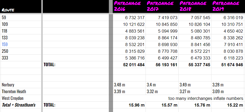 |
| As of 2023 the bus figures would be lowered due to frequency cuts In addition some train lines have been cut too, notably Beckenham Junction going half-hourly |
Using numbers that I claim to be statistics which are clearly not fair and square but are picking and choosing for the sake of my argument, I hereby state that I make my case that having frequent trains is better and more efficient than having many buses. But for this case, the powers that be cut the buses as if people don't have another option. The option being a car which defeats the purpose for the transport-powers-that-be.
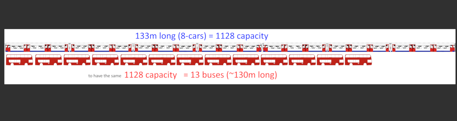
Exhibit C (Capacity)
Norwood Road
 |
| 1947 vs 2022 |
 |
| 1957 vs 2022 |
 |
| 1972 vs 2022 |
 |
| 1992 vs 2022 |
As a result of doing this project, I've also looked at West Norwood and West Dulwich, two towns in close proximity to each other, a kilometre apart even, not exactly linked by 322 but that's the closest you can get.
Thus I've stumbled on the oddity of the West Norwood Rosendale area, as there's 3 on Croxted Road alone, yet Rosendale has always been a terminus for decades until 322 came along. A crossroads by houses next to the pub, a bit unusual for a Central London route to terminate. The closest similarity I can think off the top of my head is East Ham White Horse better known as Central Park nowadays, though that's on a main road linking East Ham and Beckton. I wouldn't call either Park Hall Road and Robson Road in unison a main road but they do connect West Norwood and West Dulwich.
So the general past for these areas:
--- Note 37 was diverted via West Dulwich due to North Dulwich bridge works in the late 1990s
Had the 2 not been reduced to smithereens during the same era 42 was still irrelevant to Dulwich, what I would've done would be one of two:
2: West Norwood Vincennes Estate - Tulse Hill Estate - Marylebone
42: Crystal Palace - Gipsy Hill - Croxted Road - Milkwood Road - Camberwell - Liverpool Street
196: Norwood Junction - Tulse Hill Estate - Elephant & Castle
315: Balham - Norwood - Gipsy Road - Kingswood Drive - Lower Sydenham Sainsbury's
322: Crystal Palace - Herne Hill - Victoria
X68: West Croydon <limited stop stopping only at major stops, & Elephant> Russell Square
Two of two:
2: Gipsy Hill - West Norwood - Tulse Hill Estate - Marylebone
196: Norwood Junction - Tulse Hill Estate - Elephant & Castle
315 (fused with commercial S11 aka P15): Balham - Norwood - Dulwich Village - East Dulwich Sainsbury's
322: Crystal Palace - Herne Hill - Victoria
431: Streatham Stn - Norbury Hill - Salters Hill - Kingswood Drive - Lower Sydenham Sainsbury's - Lewisham Tesco
450: West Croydon - Dulwich Wood Park - South Croxted Road - Rosendale Road - Milkwood Road - Camberwell Green
X68: West Croydon <limited stop stopping only at major stops, & Elephant> Russell Square
This way a number of flows would be preserved whilst maintaining capacity and allowing for redundancies. The redundancies in question is not having too much busy stretches at a time. Take for example Railton Road, it's not going to spawn a full load, but it always had a service and is currently the closest to a Herne Hill-Loughborough cross-cultural-pollination.
Predominantly current-2's flows are: Marylebone - Victoria (full load) - Brixton (unload + full load again) - Norwood.
The same can be said for 432: Brixton (full load) - Norwood (full load) - Crystal Palace (unload) - Anerley (minor).
In 196's case, it's reroute to Brixton to replace the dying 172 (West Norwood Rosendale - Brixton - Kennington - King's Cross) resulted in it linking South Norwood with the tube at an even closer location: Brixton. Though it does this whilst preserving it's overlap with 68 (now 468) which is helpful for the 468, but not helpful in it being direct as it's the slowest Brixton-Norwood route, but only by a few minutes. To double that slight problem is 196/322 arguably being superfluous along Norwood Road, but both routes cater to different areas whilst happening to share that corridor, one single deck no less. A sticky situation so to speak. Therefore, a double deck route more frequent than 5 buses an hour, but less frequent than two 5 bph an hour routes of different capacity would be fine, diverting the resources to the hungrier Tulse Hill Estate which conveniently lays on the more direct path from Brixto to Norwood.
As for the 42/450 debacle. Neither route would be particularly frequent back then and now it's the 450 whose frequency dwarves the City of London route by sheer volume of the Croydon-Crystal Palace section that trods through narrow roads whilst also serving the back entrance of Croydon University Hospital. Preferably I'd have 40 which was already a Herne Hill terminator, though it being rerouted to Dulwich wasn't a bad move if we ignore the loss of capacity on Herne Hill which resulted in a late-game 42 extension to Sunray Avenue.
The X68 was popular and still has been until the pandemic hit as it's function as a peak hour only route in tandem with not serving much of 68's userbase has made it a very limited but very useful function. Even if in it's current state were to be a daily route, I have doubts people would make use of it's non-stop section from West Norwood to Waterloo, but people will make full use of it south of Norwood as it's a 468 that ends at West Croydon station.
Meanwhile for the Clapham Common end of what's now 322, something would have to be done about Clapham North's awkward turn which made it only for possible for 355s to go in one direction anticlockwise unless resorting to shorter vehicles conveniently already found on 322, a tall order for a trunk route like 355.
I'd had this post done by 25 October 2021, but left it dead as I got sick, even when I got better I effectively held this hostage. By the time I got round to making maps and other visuals for simpler stuff you'd have read in other posts, I've done Norwood as a warmup.
Postscript_2023: I've forgotten I've only done a few comparisons of Norwood Road but I've poured my energy into the Streatham High Road maps so for now I'm considering this project done. Get it off my chest, useful for me to look back on, no doubt useful for yourself and others to also reflect on.
I hope you enjoyed, stay safe and well, until the next one.
No comments:
Post a Comment